SPATIAL DATA AVAILABILITY FOR MODELLING IN GEOSCIENCES
Dr. Vít Voženílek, Ass. Prof.
Dept. of Geography, Palacky University Olomouc
tř.Svobody 26, 771 46 Olomouc, Czech Republic
Tel.: 42-68-5222451, Fax: 42-68-5225737, E-mail: VITEK@RISC.UPOL.CZ
Introduction
Geosciences are traditional natural sciences which observe, explore and explain phenomena on the Earth. The geography, geology, ecology and biology are geosciences with long history. They all handle information about Earth - space. This spatial information is hold by spatial data. They are captured for their digital storage. Present information technology allow to manage and analyse spatial data in many procedures which are involved in geoscientific researches. Their benefit is very high.
General conditions
A year 1989 can be called as "Big Bang" of GIS in Czech Republic (in former Czechoslovakia). This year changed not only political system but also economical structure of country, behaviour and thinking of people. Today GIS is well-known subject in academic audience and explore itself very rapidly. But in the Czech Republic there are still many important topics of wide GIS branch to discuss, many economic and market parameters to observe and many approaches and techniques to learn. Special issue is a contribution of Czech Republic into European GIS data policy. It is important to describe the situation in Czech Republic before 1989 in brief:
The Big Bang started new period in Czech history and changed many parts of society. The rate of these changes was high in comparison with solidity of old totalism system. The centralised structure of economy has been broken and new kinds of relationships between companies, institutions and people have been established. The free market started to be created and all parts of society tried to accept all changes. Many changes were positive but some of them or their consequences had negative impact.
Despite these changes with great importance there were several problems:
The year 1990 can be indicated as main beginning of GIS field in the Czech Republic.
Spatial data
Spatial data come from variety sources. The most commonly used spatial data are obtained from sources such as census data, land use surveys, satellite imaginary, aerial photographs and paper maps. Recent technological advances in remote sensing and computer science provide access to tremendous amounts of spatial information on a daily basis. However, spatial data often contain variations in geographical coverage, data format, map scale and data measurement. Integration of geographically referenced data from various sources is a fundamental characteristic of sophisticated software.
Traditionally, spatial data are presented in the form of hardcopy maps with pieces of information organised in separate document files. The traditional system of data measurement is not suitable for handling spatial data in the modern information age. First, hardcopy maps and document files are inefficient for organising the huge amounts of spatial data that become available on a daily basis. Second, in order for data entry and retrieval to be effective, an index system is necessary to logically connect the geographical information on a map to its associated data in document files. Such an index system alone is difficult to maintain in hardcopy form; witness the multitudinous drawers storing index cards in the catalogue room of public libraries.
Spatial modelling in geosciences
Spatial modelling serves the following two related purposes (Chou 1997):
For instance, a researcher might analyse soil erosion variance by studying a large number of environmental variables, including slope gradient, slope type, vegetation coverage and the like. A comprehensive database may include numerous environmental variables. Some variables may play a critical role in soil erosion, some may be much less significant, while others may not be significant at all. Next, correlation among variables into uncommon. Incorporating correlated variables is not a spatial model induces inflated parameter variances and should be avoided. In spatial modelling, the statistical significance of each variable can be tested in order to determine the most effective model with a minimum set of explanatory variables. Moreover, the estimated coefficient can be used as a measure of the relative weight of each variable.
The second purpose of spatial modelling answers “what-if” questions by evaluating alternative hypothetical situations. Possible situations that do not exist at the time of analysis can be generated by assigning values to meaningful variables and calibrating the model. Distributions of the study phenomenon based on hypothetical scenarios can then be mapped for examination of potential effects.
Every analyst must select the most appropriate approach to a problem - qualitative or quantitative - and then the most appropriate method(s) within the chosen approach. In general, the qualitative approach is suitable for projects in which variables are measured at the nominal or ordinal level. Quantitative analysis is generally most appropriate for projects based on variables measured at the interval or ratio level. While similarities exist between the two approaches, respective analytical procedures could be quite different. Depending on the nature of the problem and data availability, the analyst must decide which approach is more appropriate for the problem under consideration.
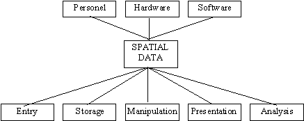
Geographical information systems
Geographical information system (GIS) is an organised collection of computer hardware, software, geographical data and personnel designed to efficiently capture, store, update, manipulate, analyse and display all forms of geographically referenced information. The primary purpose of a GIS is to process spatial or geographically referenced information. A subsidiary definition describes GIS as a computer system that stores and links geographically referenced data with graphic map features to allow a wide range of information processing, display operations, map production, analysis and modelling (Voženílek 1998).
Fig. 1 Spatial data in conceptual framework of geographical information systems
Information technologies and legislativity
The big problem in GIS data policy is in Czech legislation. There is no law, no regulation, no statue defining rules at GIS data market. Universities play specific role in GIS data distribution. Despite their bad conditions they try to accept maximum GIS knowledge, experience, teaching materials etc. Some of universities established their own courses or even workplace. They provide following activities:
Spatial data users
Spatial data users can be found in several branches. In present days these are the same like in another countries with high level of GIS activities. During last five years (since 1989) the user audience has been created and now it is explored very rapidly to reach closer level to abroad.
The users can be divided into three groups according to their ability of investing into GIS (Voženílek 1994):
1. The first group consists of state institutions and private companies dealing with many kinds of spatial data, e.g. telecommunication, utilities. This group includes all companies linked with foreign GIS subjects - vendors, dealers, consultants etc. These are able to invest in GIS activity and can be called rich.
2. The second group consists of local governments and its departments. They are the best customers. Their budgets allow to order GIS services and realise GIS projects. The level of GIS implementation is very different and it ranges from absolute GIS absence to intensive building of specialised GIS department supported its own budget and large staff. Let me name them as good customers and constant users.
3. The third group consists of university and research institutes. Both have economic difficulties and are not able to extend their capacities into new discipline - GIS - which is very money, time, experience and staff consuming. Despite this bad conditions GIS is lectured at several universities and a few research teams use GIS methods. Only these subjects employ GIS specialists. The other people interesting in GIS work in private companies or in bodies from the first and second groups. Due to the situations changed after 1989 the lecturers had to became managers finding money, grants, projects, funds, collaborations etc. This new experience established good perspectives for better jobs (not at universities). Consider there are differences in particular teams. Some of them founded specialised GIS laboratories and provide GIS education and their own GIS activities. The right name for them is still poor.
What are impacts of this situations?
The spatial data used in international projects are not common at Czech GIS market. It is due to high financial requirements for participating institutions. To be Czech GIS data suitable for European GIS data market they must be changes into acceptable format respecting international standards. But it is very money and time consuming and it means that it is a business for reach partners.
The scope of GIS in Czech Republic is wide now. It caused from a short time of GIS implementation in country. GIS state-of-art in the Czech Republic can be called "state of digitising and GIS data capturing".
Trends and perspectives
The big challenge is seen in non-profit institutions which are missing in Czech Republic. It is a consequence of bad Czech legislation. The law about non-profit organisations has not been passed yet. People in GIS branches see big opportunities in supporting their activities (projects, equipment etc.) by these organisations. I believe that projects with European GIS data contents would be supported by non-profit organisations due to their wide important and using which is highly recommended in the Czech Republic.
There is a fascinating opportunity for Czech Republic. State institutions created in last 50 years powerful data set including detail spatial information. Czechoslovakia had excellent cartography and statistics. There are long-term records about geographical and another phenomena which can be easily converted and used in European GIS databases. Then Czech GIS data can be available within European GIS data availability.
Accessibility of governmental information
Some countries, i.e. the Netherlands, has a discussion been going about the postulation that governmental information is not sufficiently available and accessible with as consequence that for trade and industry promising business opportunities remain unused. This is a discussion which can be conducted from various points of view:
In high hopes to get hold of a complex reality, many studies are conducted. But without exactly knowing the outcome one can now already predict that the results and the data upon which they are based will be questioned by others bringing forward different facts.
Marketing of governmental data
For research, governmental data and data from private companies are joined in unity on one shelf. Together they are more than the sum of their parts while forming the solution for many needs in the digital data market-place.
There has been hardly any complaint about the fact that one has to pay for data which have been produced and paid for by tax money. This is understandable. Who would be prepared to sacrifice their short-term interest for a remote general interest that cannot be quantified? On top of that, the alterance offer from the private sector is only seldom better and/or cheaper (Guikers 1998). The supply conditions of public data suppliers, including their price fixing, are rarely a reason to cancel purchase. Apparently quantity and continuity have some value if one has to invest into systems or products which have to function properly for a long term.
The incentive of public bodies are not limited to the optimatisation of their own interests. In everyday practice many types of contracts have come into existence. Custom-made making sure that the data can be applied as widely as possible (thus giving a high yield of the invested tax money), although without permitting price discrimination because statutory bodies must act carefully.
In the meantime, there are many companies that add value to the data in the form of products and services. None of these companies is expected to do an up-front investment in data, as this would nip good initiatives in the bud.
Services for the new communication era
The National Land Survey´s MapSite (http://www.kartta.nls.fi) is a www-service providing access to browsable topographic maps at various scales from all over Finland. MapSite provides services to two types of users: “Citizens´s MapSite” is available free of charge to all Finnish users, whereas “Professional´s MapSite” offers a more varied range of maps and additional services which are subject to charges (Sarkola, Makinen 1998).
MapSite is the first (and only) national Internet map service in Europe. The key to MapSite´s success has been the presence of a highly developed technical infrastructure in Finland. One in every three Finns has a mobile phone and there are only 5 million inhabitants in Finland but over 400 000 thousand Internet connections meaning 80 connections per 1 000 inhabitants, which is the highest ration in the world.
With such a large number of data communication users, more services are in demand. To meet these increasing needs the National Land Survey decided to make its services available on the Internet. Via MapSite, a user may browse topographic maps at various scales, scroll a map or search a location by place name, address or co-ordinates. The maps available by the service are at the following scales: 1 : 8 000 000, 1 : 800 000, 1 : 400 000 a 1 : 50 000. The maps can be browsed from any part of Finland at any of the scales mentioned.
The services recognises 28 000 place names and 2 million addresses to search for. The user may also point out a location on the map and obtain the addresses of the five nearest buildings. The user interface of MapSite cal also be customised. The user may select the language (Finnish, Swedish or English), the position of the menu bar and defined the size of the window.
Conclusion
To get spatial data which are necessary for modelling in geosciences is either expensive or time consuming. However there are many demands for spatial data - to be cheap (or free), updated, in suitable format and ready to use. Availability depends on ownership, capture responsibility and price. Results reflect all of them.
References:
Guikers, K. (1998): The Dilemma of the Public Mission. Geoinformatics, Vol. 1, No. 5, pp. 16 - 19.
Chou, Y.-H. (1997): Exploring Spatial Analysis in Geographic Information Systems. Santa Fe, Onword Press, 474 p.
Sarkola, P., Makinen, K. (1998): Huge Success: Fifty Thousand Users, Three Million Visits. Geoinformatics, Vol. 1, No. 5, pp. 6 - 9.
Voženílek, V.
(1994): Czech GIS Data in Context of European Data Availability. Proceedings of BRNO-GIS 1994, pp.Voženílek, V. (1998): Geografické informae
ní systémy I - pojetí, historie, základní komponenty. Olomouc, Vydavatelství UP, 174 p.